Geology Writes the Rules

AUTHOR: VIC PAULSON
On the lunar south pole, the geology is given. There is a need to find a governance framework that works within it. Landing, living, and mining each demand different terrain, and the terrain that serves one disqualifies another. No single site is favourable for all three. Proximity is what's scarce, and the terrain itself shapes what kind of governance framework can work in a given area.
The first post in this series ended with a question. If no Earth framework ports cleanly to the lunar south pole, can the lunar terrain itself tell us what governance mechanisms may work? On the Moon, geology is not an engineering input to be managed. It is a governance input that decides which rules can exist at all. The south pole is not a uniform expanse where all rules apply equally; it is a place where landing safety, surface operations, and ice extraction demand different requirements from the same square kilometer of regolith and where those demands sit in physical tension with one another.
For example: a patch of terrain cold enough to retain water ice over geologic time is too dark and cold to land on or live in. A ridge with favorable illumination and slope properties to support a habitat will not support ice formation. The site selection problem at the South Pole is therefore not only finding the best spot—it is finding spots where landing, living, and mining can sit close enough together to function as a single mission. Once you see the problem that way, the governance implications follow.
Three demands on one terrain
Landing, surface operations, and ice extraction create three different types of demand on the same terrain. We capture those demands as three favorability indices. Each index weighs the same physical features differently because each phase has different requirements.
| LFI - Landing Favorability
“Can the lander touch down here without breaking?”
Slope dominates, plus surface roughness and thermal stability through descent.
| SOFI - Surface Operations Favorability
“Can the crew stay alive and productive here?”
Illumination dominates. Long sun exposure for power and thermal control, moderate temperatures, and traversable slopes for rovers and crew.
| IFI - Ice Favorability
“Is there water ice here in usable form?”
Permanent shadow dominates. The extreme, stable cold inside permanently shadowed regions is what lets volatiles persist over billions of years.
Each index is scored on a continuous scale and then binned into four ordered classes: poor, marginal, favorable, and strong. Separately, each phase has a viability floor. A site that falls below the floor is not merely poor; it is disqualified for that phase and does not receive a class at all.
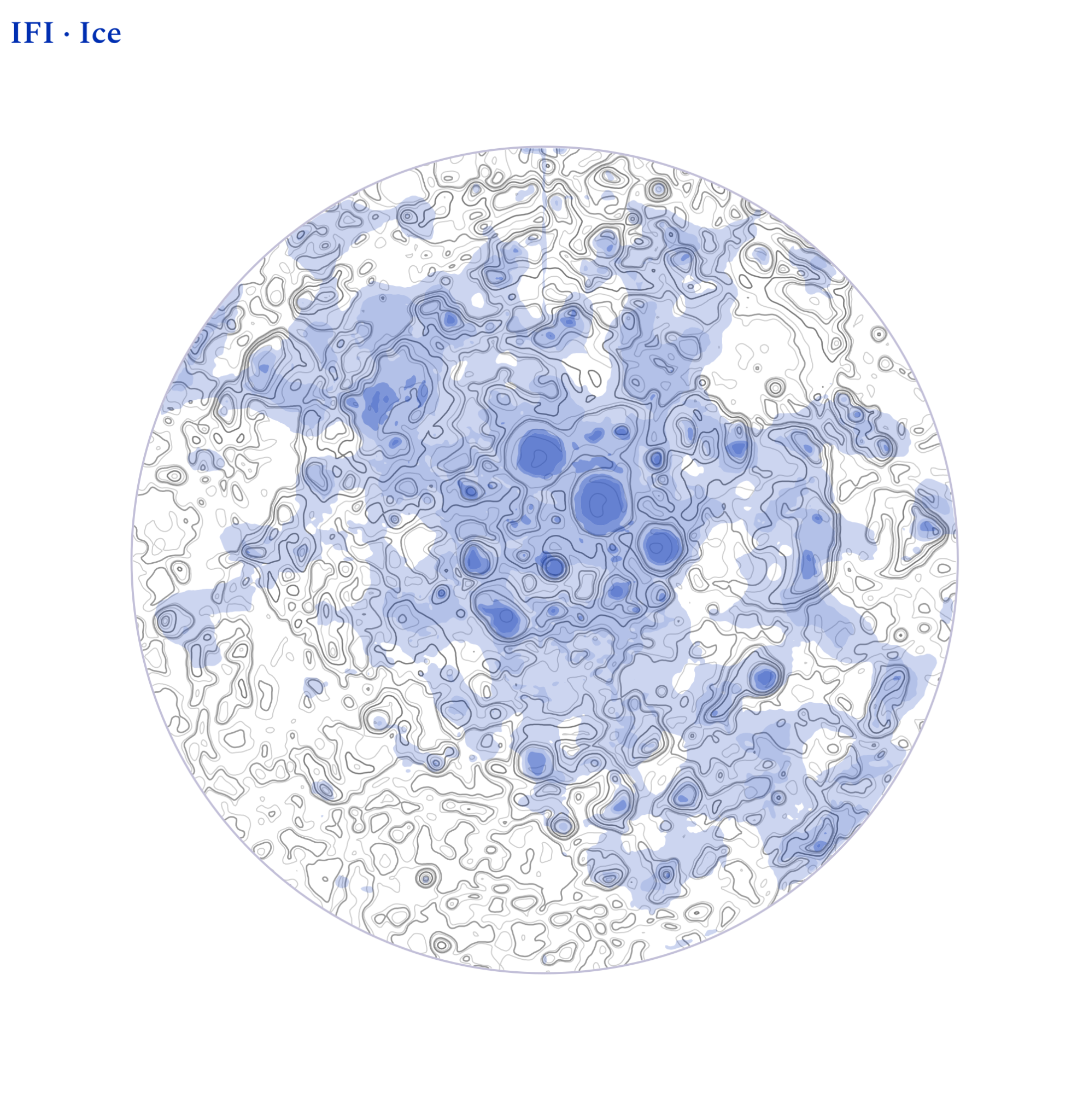
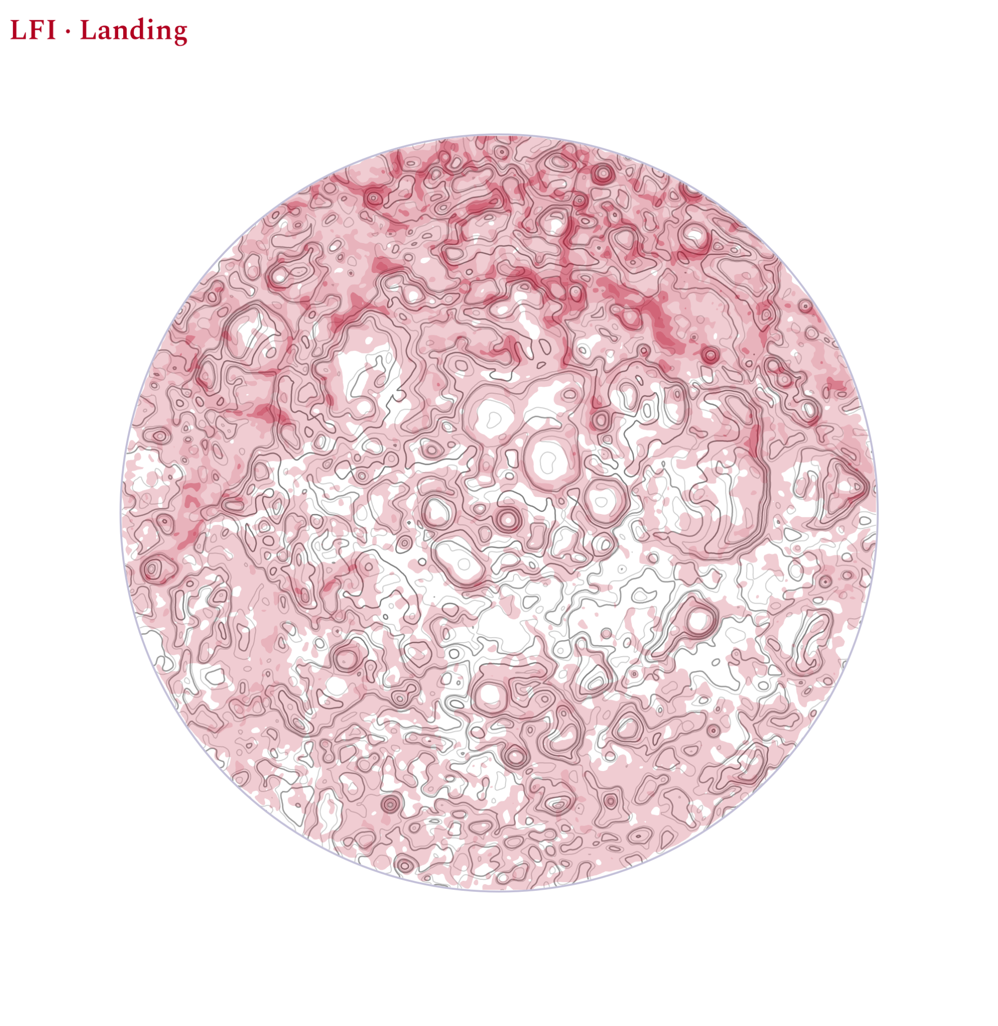
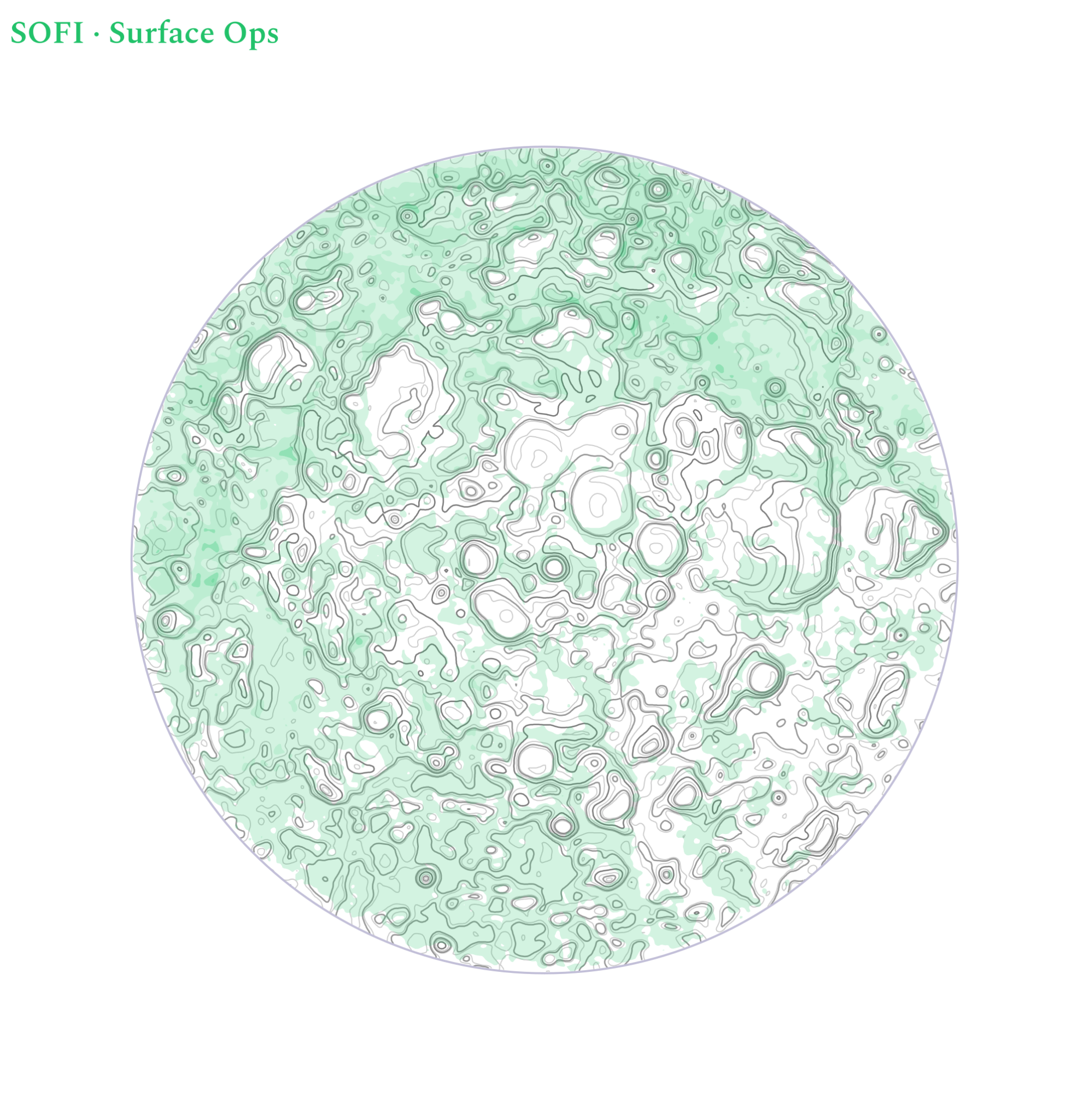
Fig 1. Saturated color indicates favorable ground, with pale saturation indicating ‘low’ viability. Strong viability regions for all three phases never coincide.
The same feature, three meanings
Take one terrain feature and watch its meaning shift across the three demands. A six-degree slope is comfortable for a rover and fine for a habitat pad, so it barely moves SOFI. The same slope is marginal for a lander. For ice, it is close to irrelevant, because what matters there is shadow, not steepness.
Illumination runs the opposite way. Continuous sun is the single best thing that can happen to surface operations and the single worst thing that can happen to ice. The feature that powers the habitat is the feature that would have sublimated the resource away. This is why a rule written for the lunar surface as if it were one kind of place produces guidance that operators cannot follow.
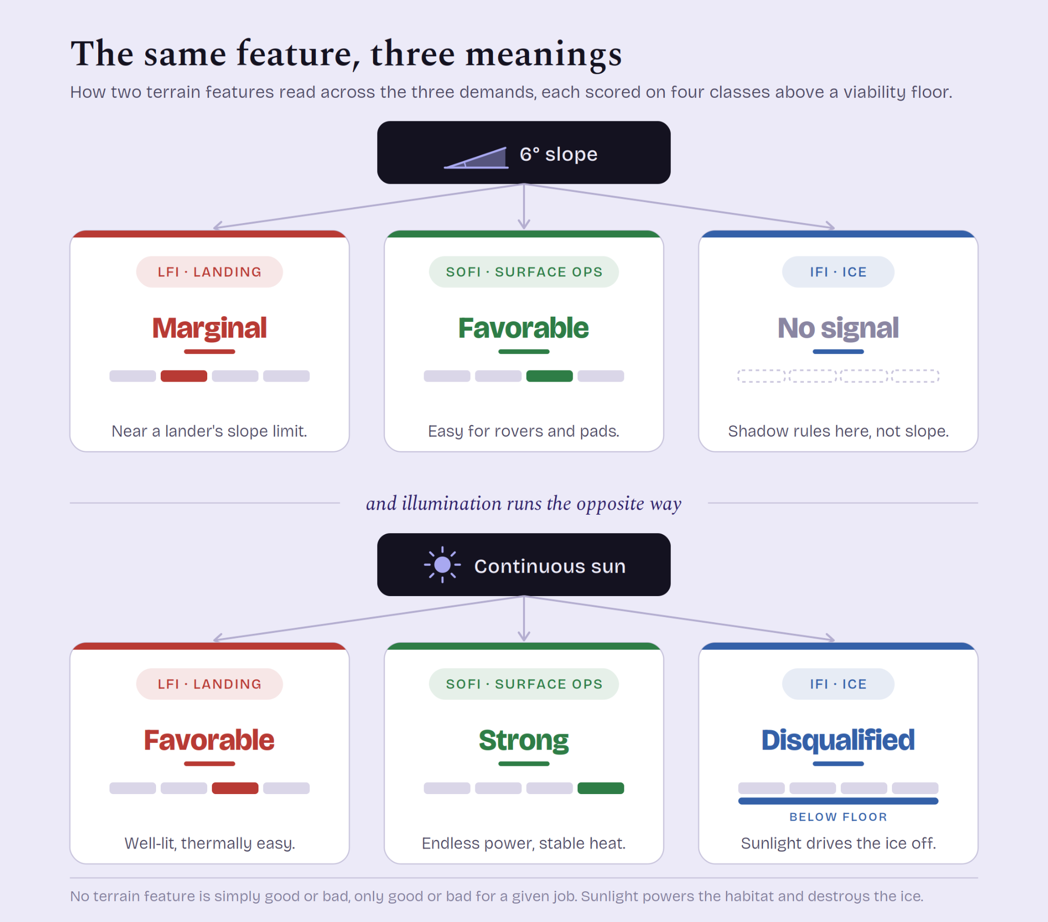
Fig 2. The same feature, three meanings. One slope and one illumination condition, scored against all three indices
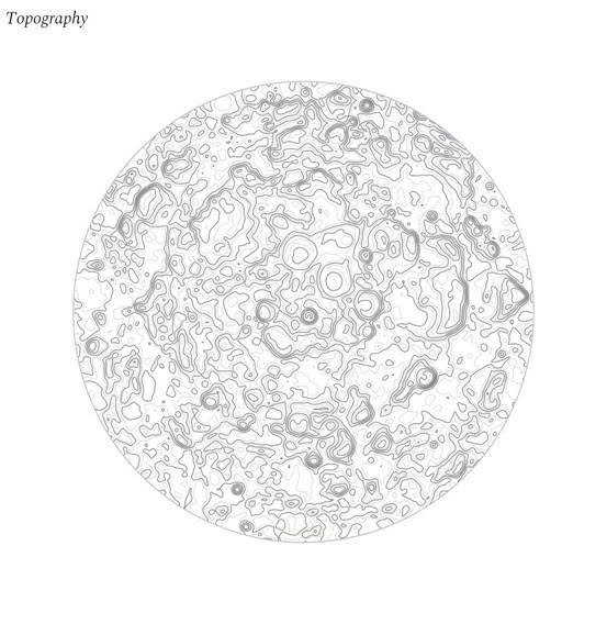
Fig 3. The raw terrain, before any weighting. LROC south-polar elevation.
No pixel does all three
When layering the three indices into a single image (landing favorability shown in red, surface operations in green, and ice in blue), all phases never overlap. The best sites for landing and operations are located on illuminated ridges and crater rims. The sites most favorable for potential water ice are located in the permanently shadowed regions. The conditions that make a place valuable for ice are the conditions that make it useless for nearly all other operations. A perfect site, suitable for all operations, therefore, does not exist.
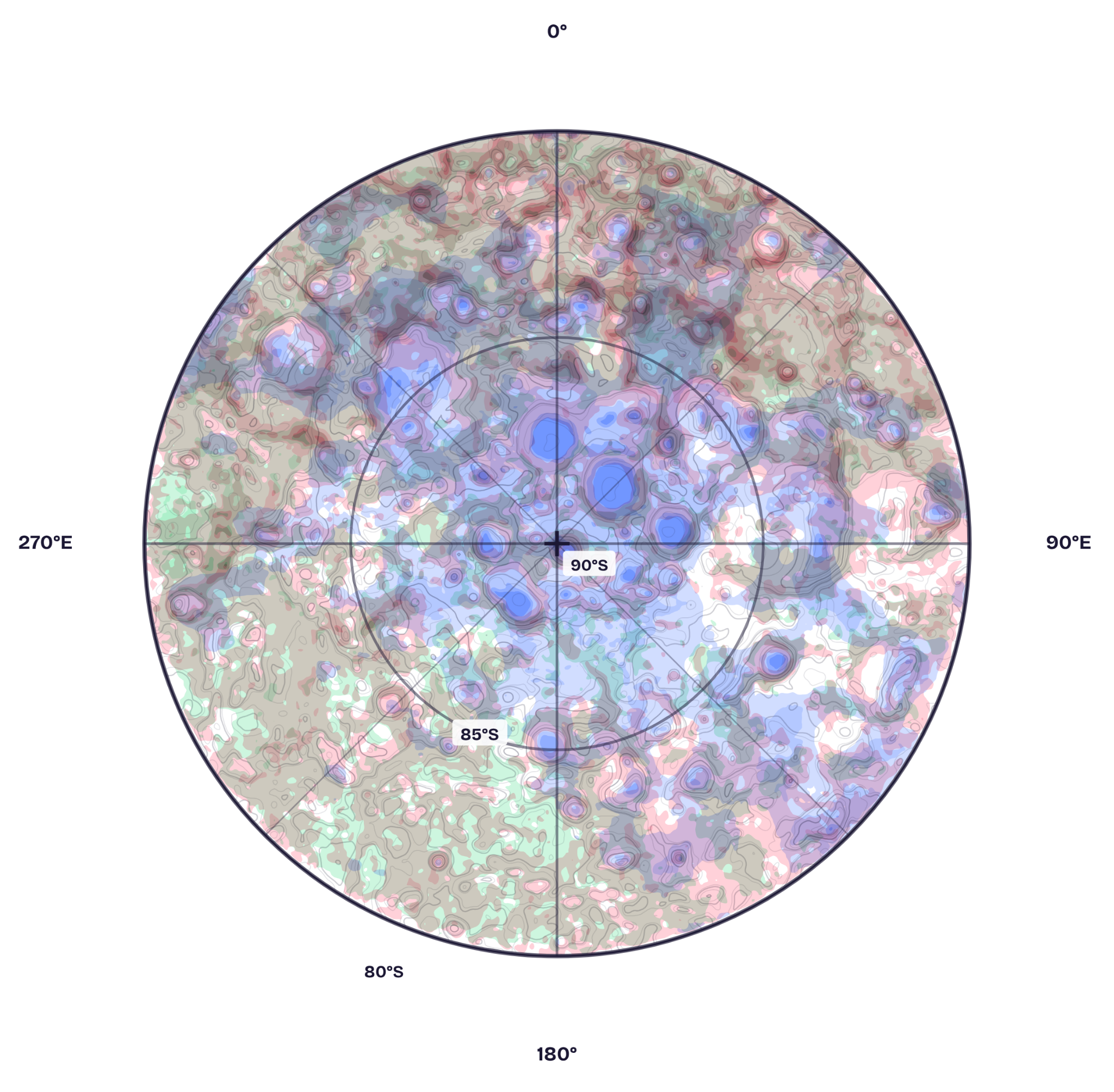
Fig 4. Composite favorability. Where phases overlap, their colors mix and darken: landing over ice turns purple, and a site strong in all three would fall to black. No location does.
If no site is favorable for all phases, then the planner’s real question changes from "where is the best site?" but "how tightly can I pack the three sites I need?” A mission needs a safe landing approach, an area to set up a habitat, and ice within reach. What determines whether those three can function as one mission is the distance between them. What is scarce, in other words, is not a place; it is proximity. A strong ice floor with no landable ground within rover range is not a resource a mission can use. A perfect landing pad fifty kilometers from any shadow can not utilize ice resources. The proximity is also not arbitrary; it is the distance a rover can cross and return from on a fixed power budget.
A lunar base therefore works like a city. The airport, the housing, and downtown are never in the same location, yet the city functions because they sit close enough to connect. Landing is the cities' airports, the safe place to arrive. Surface operations are the neighborhoods, the places to live. Ice is downtown, where the resource that pays for everything sits. Nobody expects to land, live, and mine in a single location any more than they expect to live on a runway. What makes a city, or a lunar base, viable is not one perfect location it is complements within reach of each other.
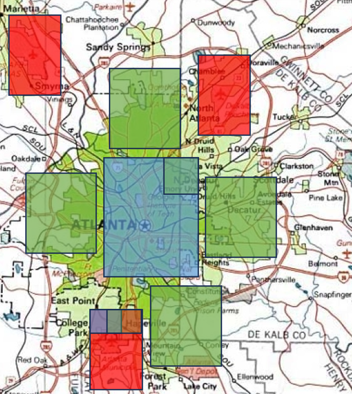
Fig 5. The city analogy. Atlanta’s airport, neighborhoods, and downtown never overlap, yet the city works because they sit within a short drive.
The geologic data inputs
The favorability indices are convenient summaries. Underneath them the planner confronts a stack of independent measured layers, and each one disqualifies most of the map on its own.
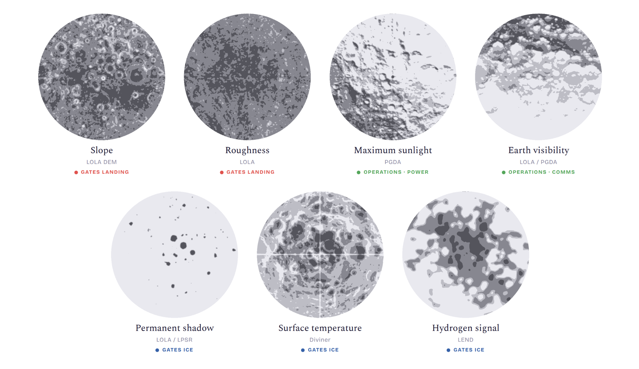
Fig 6. The independent LRO layers behind the indices, each measuring one physical property of the pole.
Read across the stack. Slope and surface roughness decide whether a lander survives touchdown. Maximum sunlight decides whether a mission can be powered by solar arrays and held above its survival temperature through the long polar night. Permanent shadow, temperature, and the hydrogen signal decide whether usable ice is actually there. Each of these is a real measurement, and each one, on its own, is a statement about lunar geology. None of them is a decision a mission planner can act on.
That gap is the reason the favorability indices exist. Folding the raw layers into LFI, SOFI, and IFI does more than compress these many maps into three. It changes what the map is for. A slope map or a temperature map describes what the surface is. A favorability map describes what the surface is good for. By weighting each layer according to what a mission phase actually needs and combining the layers into a single index, we turn a geology product into a planning product. The result is no longer a map an engineer has to translate. It is a map an engineer can read directly.
Where are missions going?
Every mission to the lunar south pole must land such that a spacecraft can touch down close to sites that hold ice. Plot the actual touchdown coordinates of the missions that have already flown (red dots), together with the regions Artemis has selected for the ones that haven't (teal boxes), and both sets land in locations where landability and ice access have high proximity.
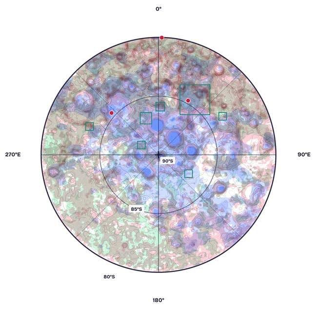
Fig 7. Flown points (red) and Artemis III candidate regions (teal) on the favorability composite.
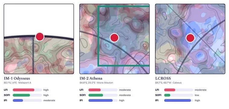
Fig 8. The three polar points at true coordinates, with the index reading sampled at each.
IM-1 Odysseus. Odysseus, February 2024, was the first American soft landing since Apollo and the first commercial one, flown under NASA’s CLPS program to prove a private lander could reach the polar region and set down a stack of technology-demonstration payloads. That is a landing objective, not an ice objective, and the indices under the dot read exactly that way: high LFI, high SOFI, only moderate IFI. The framework called it landable, and it was, barely. Odysseus met a 12-degree slope inside a degraded crater and tipped. High LFI is a probability, not a guarantee, and reducing that probability's error bars was part of Odysseus’ mission. The payloads carried, terrain-relative navigation sensing and plume-surface imaging among them was flown to convert modeled landing risk into measured landing risk.
IM-2 Athena. Athena, in March 2025, carried NASA’s PRIME-1: the TRIDENT drill and the MSOLO mass spectrometer, built to bore a meter into Mons Mouton and read the cuttings for water ice and volatiles, with a hopper meant to jump into a nearby shadowed crater and measure hydrogen. That is an ice-prospecting objective, and the indices match it: moderate LFI and SOFI against high IFI. Athena did not pick Mons Mouton because it was easy to land on. It picked it because the ice favorability is high there, and it accepted the landing risk to get next to it. Athena came down about 250 meters off target and ended on its side in a 20-meter crater. The terrain that earns the high IFI is the same terrain that drags LFI down to moderate and tips a lander.
LCROSS. LCROSS, October 2009, had the simplest objective in the record: hit a permanently shadowed crater hard enough to throw a plume, then read the plume for water. The indices say what the objective says: moderate LFI, low SOFI, high IFI. The operations score was irrelevant because nothing had to operate, and the landing score was irrelevant because nothing had to land. It needed one index: ice.
The Artemis candidates. The teal boxes are the nine regions NASA carried from thirteen in 2022 down to nine in 2024, all within six degrees of the pole. Every box lands on an illuminated ridge that reads high for both LFI and SOFI, and every box keeps shadowed ice within reach.
What does this mean for lunar policy?
Here is where geology becomes policy. Almost every governance instrument we might borrow from Earth allocates a point or a parcel. A crater. A claim. A safety zone drawn around a single asset. But if the thing that makes a mission possible is a bundle of adjacent complementary terrain, then granting a point governs the wrong object entirely.
Grant the ice floor alone, and you have handed someone a resource with no way to reach it, which forces conflict at the edges where their approach has to cross someone else’s ground. Grant a generous parcel, and you lock up illuminated ridges that a dozen other missions need and that the holder cannot use. Either way, the rule is fighting the terrain. A framework that does not encode mission phase bakes in conflict from the first allocation.
The terrain is telling us what the unit of governance should be. Not a spot. A bounded set of complementary terrain, sized to the mission that uses it, defined by what the ground can actually do at each location inside it. That is a different object than a claim, and it needs a different paradigm.
Lauren Victoria Paulson (Vic) is a 2026 Open Lunar Fellow. Her fellowship work centers on a digital simulation sandbox for testing DLA governance regimes at the lunar south pole, where players act as lunar operators making real asset deployment and resource extraction decisions under different governance configurations. The goal is to make the consequences of governance choices visible and testable before they get codified.