Building Trust Across the Divide: How Evidence-Based Designated Lunar Areas Resolve Deadlocks

AUTHOR: AARON MACKEY
Aaron Mackey is a 2026 Open Lunar Fellow working on geospatial data applications professional leveraging remote sensing solutions to advance open-access frameworks for designated lunar areas and peaceful lunar development.
Introduction
The previous post in this series walked through what a Designated Lunar Area (DLA) actually looks like in practice: the three concentric rings (Core Operations Zone, Harmonization Zone, Coordination Area), the Ground Rules Toolkit that translates those rings into decision logic, and a test scenario showing three operators, a lander, a beamed-power network, and an extraction site, all successfully coordinating because each had a shared incentive to avoid conflict and a tool to do so (Mackey, 2026).
That scenario worked because all three operators wanted the same thing: predictable, low-friction access to a shared crater. But what happens when operators aren't cooperative? Who validates a registration when there's a dispute? How does the system hold when the actors converging on a site don't share an underlying decision framework, let alone a political relationship?
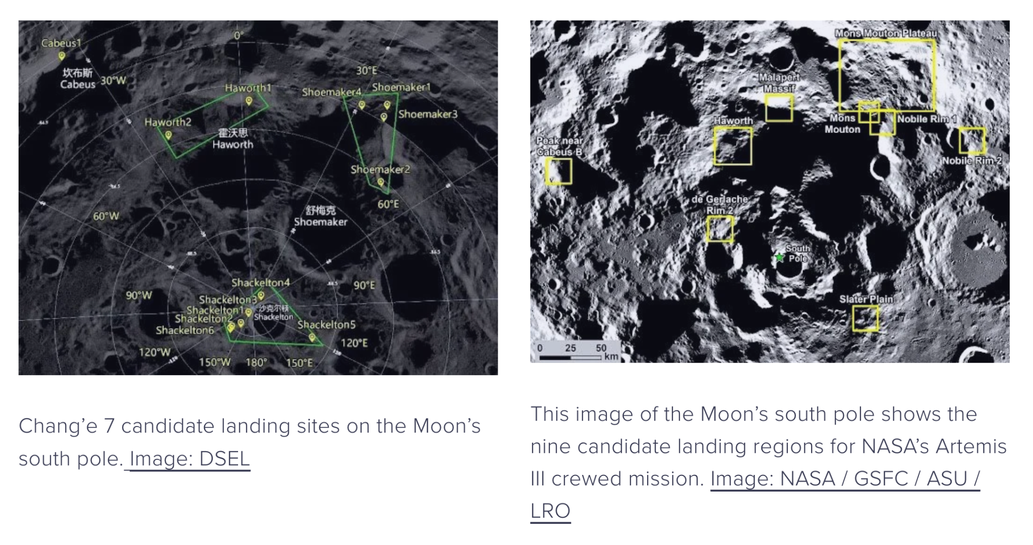
The Moon's highest-value terrain, the permanently shadowed regions near the south pole, will draw missions, and already these missions are aligned along geopolitical fault lines.
Artemis Accords signatories now number 68 nations, operating under a framework built around transparency, interoperability, and U.S.-led commercial access norms (U.S. Department of State, 2026). The International Lunar Research Station (ILRS) consortium, led by China and Russia and joined by additional partners since 2021, represents a competing vision with different assumptions about data sovereignty and multilateral decision-making (China National Space Administration & Roscosmos, 2021).
Each side has their critiques of the other: ILRS signatories argue the Artemis Accords encode American commercial interests under the language of universal norms; Artemis signatories point to ILRS's comparative opacity about governance mechanisms and data-sharing commitments. A handful of nations such as Thailand and Senegal, have signed both the Artemis Accords and the ILRS agreement. (Britannica, 2026). Neither framework, as currently constituted, has an answer for two missions from opposing blocs converging on the same crater rim with overlapping hazard footprints. This is the uncooperative-operator problem from the last post, except the lack of cooperation isn't a matter of bad faith but a matter of two actors who don't recognize the same governing authority in the first place. This post argues that the DLA framework and the Ground Rules Toolkit don't need them to.
Why the Deadlock Exists
The deadlock isn't primarily a resource problem. The deadlock is about authority and who gets to set the terms of lunar operations, and who has to accept terms they didn't write. The Artemis Accords are not a treaty. They carry no binding legal force; they're a set of voluntary commitments that operationalize the Outer Space Treaty for the commercial era (NASA, 2020; United Nations, 1967). That voluntary structure is also their limitation, since they bind only the actors who choose to sign, and they were drafted through a process that ILRS partners weren't part of. The ILRS framework, for its part, has not published the kind of detailed operational or data-sharing commitments that would allow an outside operator to evaluate in advance what coordinating with an ILRS mission would actually require.
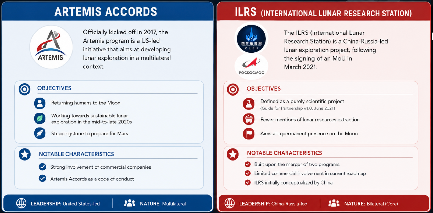
The two lunar bloc frameworks at a glance.
This is precisely the scenario the Ground Rules Toolkit's overlap logic was built to handle. As a refresher: Core Zone overlaps trigger mandatory deconfliction, Harmonization Zone overlaps require negotiated coordination, Coordination Area overlaps require notification. However, the Toolkit's logic assumes both parties are checking the same Ledger and recognize the same obligations once a flag fires. An Artemis-aligned operator and an ILRS-aligned operator have no guarantee of either.
So the deadlock, reduced to its mechanics, is this: the spatial logic is sound regardless of who built it, but the political logic (ie, who has standing to require compliance) is still contested. If the only way to use DLAs is to first resolve the political question, the framework is less likely to get used where it matters most. The way out of the deadlock is to stop treating them as the same question and break them into their constituent parts in an evidence-based framework.
Why Evidence-Based Governance Works
Elinor Ostrom's research on governing the commons offers the relevant move here. Ostrom's central finding was that decentralized, polycentric governance, where actors directly stake their own interests in managing a shared resource, outperforms top-down regulation, and that this holds even among actors who don't share a central authority (Ostrom, 1990). Polycentric doesn't mean harmonized. It means each actor is operating under their own rules while still responding to shared, observable conditions in the commons they're operating in.
That's the structural opening for Artemis and ILRS operators alike. Two operators don't need to agree on whose accords govern the Moon to agree that a particular dust dispersion model accurately predicts how regolith behaves at 1/6 g (Metzger, Smith, & Lane, 2011). Physics doesn't have a political affiliation. A Core Operations Zone calculated from lander mass, thrust profile, and terrain shielding produces the same hazard radius whether the lander is American, Chinese, or Emirati, and that calculation can be checked, independently, by anyone with the methodology and the inputs.
This is the same principle that lets ICAO aircraft separation standards function across nations that disagree about nearly everything else (International Civil Aviation Organization, 2016). Countries don't negotiate stall speed bilaterally. They agree the number is verifiable, and they build separation rules on top of it. The standard doesn't require political alignment. It requires that the underlying claim be checkable.
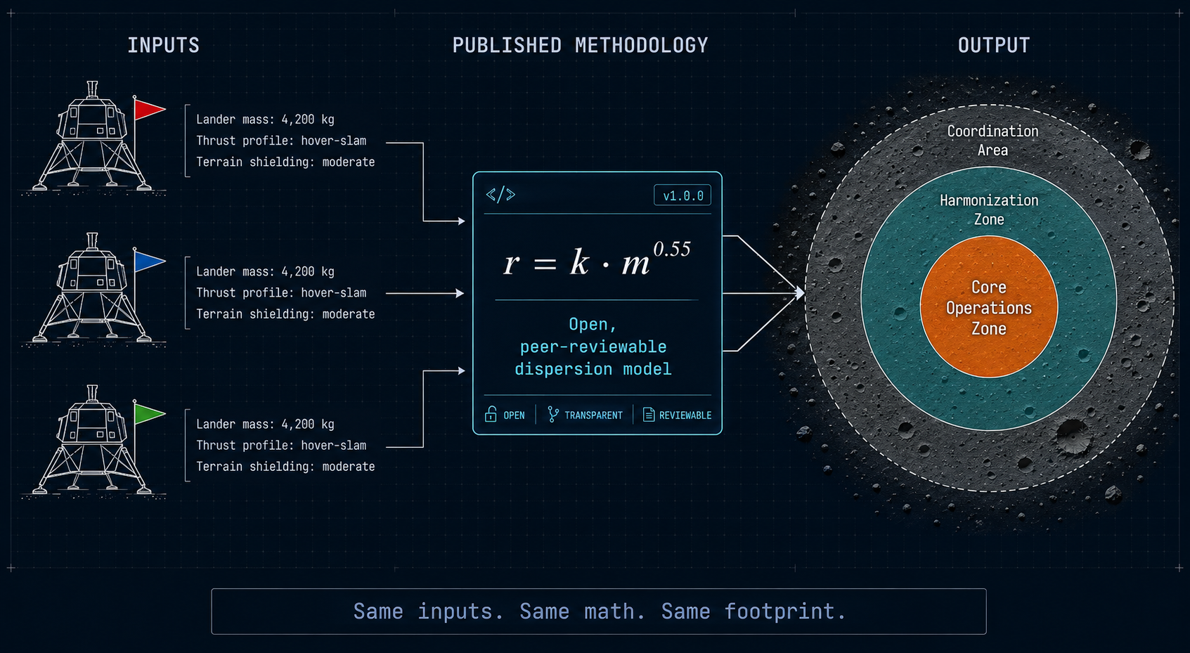
The DLA framework already has this property baked in. Recall that the Harmonization Zone's legitimacy depends on the operator publishing the model behind their declared hazard boundary, be it a dust dispersion simulation, thermal plume estimate, comms interference radius, etc, specifically so neighbors can evaluate whether the buffer is honestly sized. That requirement wasn't designed with Artemis/ILRS in mind, but it's exactly the mechanism that makes cross-bloc coordination possible. An ILRS mission doesn't have to accept Artemis governance to evaluate whether an Artemis operator's published dust model is physically plausible. They just have to be able to see it.
Addressing the Uncooperative Operator Problem
Two very different kinds of non-cooperation could be expected in the lunar context.
Bad-faith non-cooperation is an operator within a shared framework who simply refuses to participate: doesn't register their DLA's, doesn't publish hazard models, doesn't respond to Coordination Area notifications. The incentive structure punishes this behavior without requiring enforcement. An operator who won't share real data defaults to declaring maximum buffers with no time-bound constraints, which wastes their own coordination space and signals bad faith to customers, insurers, and agency partners who increasingly expect verifiable, responsible operations as a baseline (Mackey, 2026b). Transparency becomes a market signal, and operators who withhold it pay a reputational and commercial cost even in the absence of a regulator forcing the issue.
Structural non-cooperation is different, and closer to what Artemis/ILRS actually presents. It's not that an ILRS operator refuses to coordinate, it's that there's no shared coordination infrastructure, no shared ground rules, and no agreed authority compelling either side to use one even if they wanted to. This is an infrastructure gap, not a gap in goodwill, and the incentive solution applied to bad-faith non-cooperation doesn't resolve this. That argument assumed both operators were at least nominally inside the same framework.
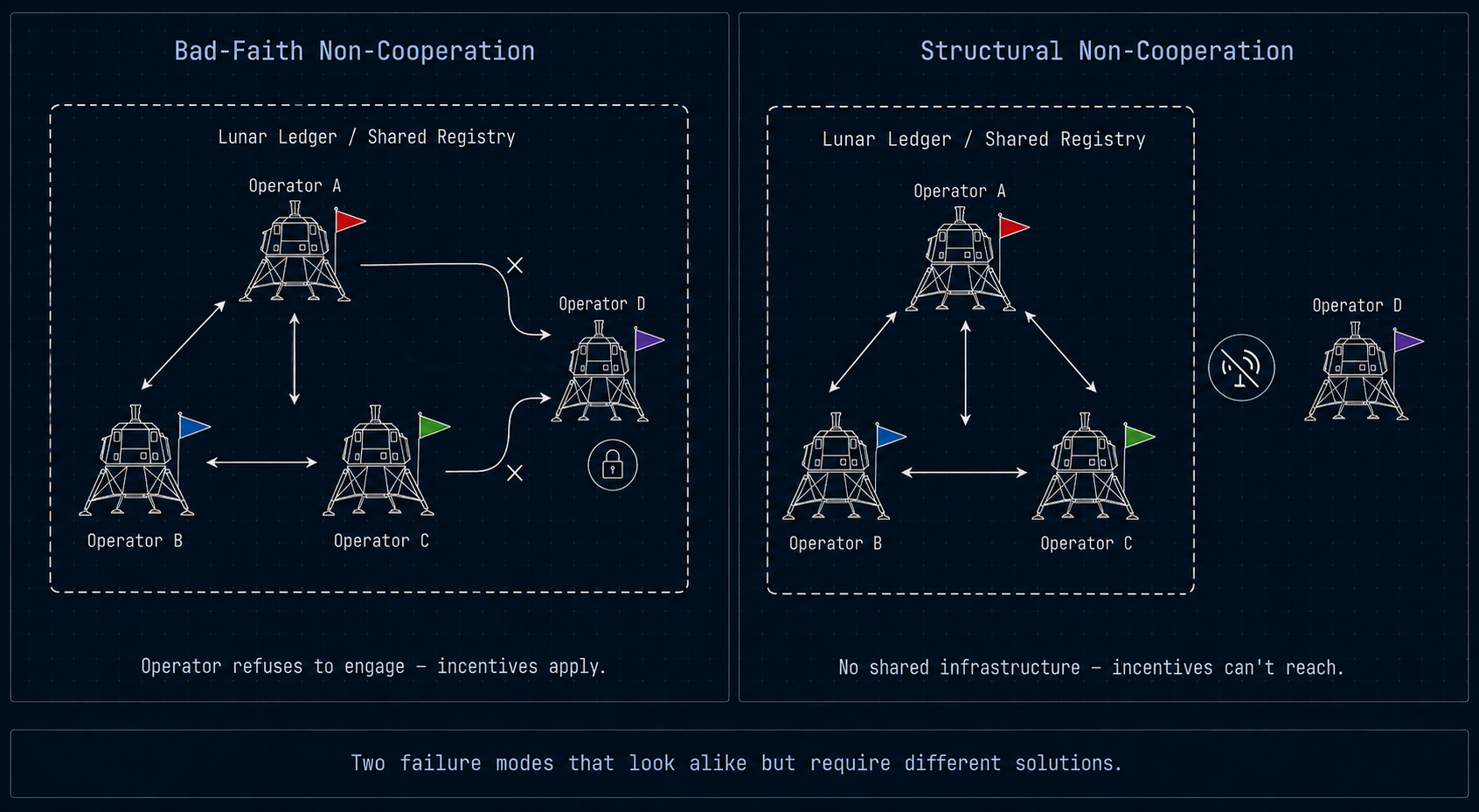
The resolution has to operate at the level of methodology rather than the level of platform. If the hazard models underlying DLAs, whether they be dust dispersion formulas or thermal plume estimates, the same Core/Harmonization/Coordination logic is published as open, peer-reviewable methodology rather than proprietary to any single registry, an ILRS operator can compute and publish a DLA-compatible footprint without being involved in the Artemis Accords. While they don't need to recognize Artemis Accord authority or broader UN authority, they can use math that produces a verifiable, checkable hazard boundary, expressed in a coordinate system, and plan their ops around those areas.
This is demonstrative of how a narrower claim than a shared governance body can still be effective. It is a claim that they can converge on a shared measurement standard without converging on a shared authority. In the same way, two ships flying different flags both trust the same depth soundings on a nautical chart without one navy reporting to the other.
It doesn't fully solve structural non-cooperation. If an ILRS mission declines to publish anything at all, the framework has no lever; that genuinely is an unresolved case. But it shrinks the problem from two political blocs with no common ground to more of a methodology gap that's shrinkable through open-source tooling. This is a problem that coordination infrastructure can actually chip away at, even before the political question is settled.
What This Looks Like in Practice — Extending the South Pole Scenario
Each post began with an imagined scenario, so it is appropriate to end our series much the same way. Let’s return to the scenario from the last blog post involving three operators, A, B, and C, all implicitly operating under the same registry and the same set of assumptions.
Operator D now arrives in the same south pole region: an ILRS-affiliated mission conducting its own extraction survey, not registered on the Lunar Ledger, operating under no Artemis-aligned framework. Operator D has no obligation, political or legal, to share data before their approach and landing.
Under a purely registry-dependent system, Operator D is invisible. Operators A, B, and C have no way to know D's intended landing site, no way to flag overlap, and no mechanism for notification. This is the structural non-cooperation case at its worst and a real operational hazard for all four operators.
Despite Operator D being opaque in its data-sharing, operators A, B, and C are not. Everything conducted on the lunar surface has utilized the Designated Lunar Areas methodology and is available for review. While Operator D is disinclined to share data, it still behooves them to evaluate all variables on the surface for this landing, including other operations. Operator D internally reviews the shared data of the other operators in the crater and tests their logic to confirm the hazard profiles present at the landing site. Finding that all three operators' math checks out, Operator D determines that the area 30km away from Operator A's previous landing is an ideal site for their mission. Operator D lands in the crater, and while Operators A, B, and C can infer the new actor's intended ops area, their own transparency subtly pushes the new actor into alignment with the DLA framework.
This scenario above doesn't require Operator D to accept Artemis governance. It doesn't require them to share data or coordinate. It is the agreed utilization of a transparent and testable coordination framework by other actors that steers lunar operations toward a shared reality. Even without Operator D opting in, the shared transparency lowers all other actors' risk. That's a far lower bar than political alignment for lunar operations, and it's a bar that's already in most national space agencies' self-interest to clear.
What the Coordination Infrastructure Can and Can't Do
The honest version of this argument has a ceiling. Evidence-based DLAs cannot make an operator who refuses to publish anything legible. They cannot substitute for a binding dispute-resolution mechanism if a genuine conflict occurs between actors who recognize no common authority.
What evidence-based coordination can do is narrow the version of the problem that's actually intractable. It separates the authority question, which is genuinely unresolved and may stay that way for a long time to come, from the measurement question, which doesn't have to be. Two operators who will never agree on whose accords govern the Moon can still agree that a published, checkable hazard mode that can be peer-reviewed or entered into a court of law is more trustworthy than an unpublished one. That agreement, small as it sounds, is the same load-bearing mechanism that lets operators resolve their conflicts before they become crises.
The Moon is not yet congested, and the actors who will define the first decade of sustained operations, be they Artemis-aligned or ILRS-aligned, are still in planning phases, still reachable, still in a position to adopt methodological transparency before live operations frame every decision in a Cold War oppositional framework. The current window doesn't require the geopolitical deadlock to break first. It only requires a critical mass of operators to keep publishing mission data in a shared environment that the other side can check, test, and maybe one day join.
References
China National Space Administration & Roscosmos. (2021). International Lunar Research Station (ILRS) Guide for Partnership. Retrieved from https://www.cnsa.gov.cn/
International Civil Aviation Organization. (2016). Procedures for Air Navigation Services — Air Traffic Management (Doc 4444, 16th ed.). Montreal: ICAO. [NEW — supports the ICAO separation-standards analogy]
Mackey, A. (2026). Lunar Radius Framework (v0.6). Retrieved from https://github.com/aaronmac24/lunar-radius-framework
Metzger, P. T., Smith, J., & Lane, J. E. (2011). Phenomenology of soil erosion due to rocket exhaust on the Moon and the Mauna Kea lunar test site. Journal of Geophysical Research: Planets, 116(E6).
NASA. (2020). Artemis Accords: Principles for Cooperation in the Civil Exploration and Use of the Moon, Mars, Comets, and Asteroids for Peaceful Purposes. Retrieved from https://www.nasa.gov/artemis-accords/
Open Lunar Foundation. (2025). Lunar Operations Field Guide: Lunar Designated Areas (C. Tiballi, Author). Retrieved from https://www.openlunar.org/publications/lunar-areas-field-guide
Ostrom, E. (1990). Governing the Commons: The Evolution of Institutions for Collective Action. Cambridge University Press.
United Nations. (1967). Treaty on Principles Governing the Activities of States in the Exploration and Use of Outer Space, Including the Moon and Other Celestial Bodies. Retrieved from https://www.unoosa.org/oosa/en/ourwork/spacelaw/treaties/outerspacetreaty.html
U.S. Department of State. (2026). Artemis Accords. Retrieved from https://www.state.gov/bureau-of-oceans-and-international-environmental-and-scientific-affairs/artemis-accords
Aaron Mackey is a 2026 Open Lunar Fellow working on geospatial data applications professional leveraging remote sensing solutions to advance open-access frameworks for designated lunar areas and peaceful lunar development.